I finally got around to writing my review of the trails along the St. Joseph Pathway, part of the larger network of Fort Wayne Trails and the Rivergreenway. It was a really pleasant run that really puts the beauty of Fort Wayne's rivers, parks, bridges, and some other landmarks on display.
I ran a full 12 miles without getting bored and the parks offered enough places along the way to stop and get hydrated. I'll definitely run the St. Joseph Pathway again as I continue training for my first full marathon. Here's the route I took for this review:
Cost (5/5)
It's free!
Facilities (4/5)
There are facilities at Shoaff Park, Johnny Appleseed Park, and at The Old Fort (subject to park hours). I was able to get water from the drinking fountain at the Johnny Appleseed Campground.
Distance (10/10)
Right now, the St. Joseph Pathway is about 6 miles one way. I did an out/back, with a little spur through Headwaters and over the MLK bridge that ended up at around 12.5 miles. I didn't get bored, since I got different views of the St. Joe River in each direction of the run.
Short Runs (4 miles or less): 10/10
Medium Runs (4-10 miles): 10/10
Long Runs (10+ miles): 10/10
Surface (5.5/10)
It's basically all the standard Rivergreenway paved trails, except for the stretch through The Plex/Heffner Fields area that gives you a mix of fine crushed gravel and some uncomfortable construction-grade gravel. The surface and trails are clear from debris.
Here's the primary surface. Wide, paved trail.
There's a mile of gravel, some of it too large for comfort, on the stretch between St. Joe Center Rd. and the IPFW campus.
This part has more finely crushed gravel.
There are a few boardwalks like this near river crossings.
The greenway surface just north of Downtown Ft. Wayne.
Terrain (5.5/10)
It's pretty much completely flat. Here's the elevation profile from my run:
These are always a bit visually misleading, but you'll notice that the entire pathway sits between about 745 and 780 feet above sea level, and probably 90% of it is between a 10-foot range of only 755 to 765. So, you'll have to do some Fartleks or tempos to get a good workout on this route. But, it's great if you're looking for an easy long run or if you want to set a 10k PR.
Scenery (3.5/5)
The St. Joseph Pathway has some of the best scenery on the entire Rivergreenway with its river views and some really great spots to frame the downtown Fort Wayne skyline. It also has some of the worst scenery on the stretch just south of Johnny Appleseed Park along Spy Run Avenue between Parnell and State. It has you running right alongside the river, but you don't really get to see it at all because of all the tree & brush cover. Adding insult to injury, you're running around (and even through!) power line structures. That ugly stretch spits you out into some ugly commercial/industrial zones for a little bit before going through more pleasant downtown residential areas.
The pathway gets you some great shots of the St. Joe River, the pedestrian bridge at IPFW, The Old Fort, The downtown Fort Wayne skyline, those Riverfront benches, and a few other unexpected things. I really enjoyed getting to see the city in ways that I hadn't before in a (mostly) pleasant setting.
The IPFW Pedestrian Bridge
The St. Joe River
Just a little driftwood
Crossing the St. Joseph River at St. Joe Center Road
St. Joseph River Near Shoaff Park
The St. Joseph River along Elizabeth Street.
River view from the pedestrian bridge connecting The Old Fort to Headwaters Park
View of downtown Fort Wayne from the pedestrian bridge connecting The Old Fort to Headwaters Park
Downtown (Old Fort, Water Treatment Plant, Headwaters Park, MLK Bridge)
Ugly Power Lines
Probably the ugliest stretch of the pathway takes you around and under a bunch of these monsters.
Cover (3.5/5)
Most of the trail is lined by trees, so there's pretty decent coverage from crosswinds. If you run early, the trees will provide some shade. Unfortunately, there are still a few areas where you're entirely exposed to the sun on hot days.
Traffic (8/10)
It's impressive that residents can get all the way downtown from Shoaff on the Rivergreenway, but there are a couple of minor drawbacks. First, there is one busy street crossing - at State Street - that I had to wait for, and that caused some headaches for a family on bikes in front of me. Second, there are a couple of small stretches that share the road (one near Shoaff, and the other in Johnny Appleseed Park). Other than that, trail traffic isn't an issue and most of the run is relatively peaceful (especially if you get up and run early before the city gets moving).
Crossing over State Street isn't so great
Markers (1.5/3)
The more established sections of the pathway, closer to downtown after you pass through Johnny Appleseed Park, are clearly marked every quarter mile on the trail itself along with a few signposts. The newer sections north of Coliseum Boulevard are more haphazardly marked with signage. I got lost the first time I tried to get across Coliseum from The Plex and had to abandon my plans and turn back (as detailed in this earlier post).
Family (5/5)
The paved sections are perfect for a jogging stroller or for your kids to join on their bikes. You couldn't do the whole trail like that, though, since some of it is roughly paved near the North end of The Plex. There's plenty for the family to do at Shoaff (playgrounds, pond, trails, family programming, etc.) and of course downtown if you start at Headwaters.
Connections (3/3)
You can connect to the other main Rivergreenway pathways and run/bike pretty much forever. I think you'll eventually be able to connect to the Pufferbelly Trail and get to the far Northwest side of Allen County.
Safety (3.5/5)
I docked points here just because of the crossing over State Street and because I came upon a weird situation in Lawton Park (just north of Headwaters Park off the Pathway). I ran toward the Pavilion in Lawton Park to (hopefully) get some water, when I noticed a man sitting alone at a table with two black duffle bags. He saw me and ran away to hide. I left the park immediately to get back onto the pathway and incidentally encountered the man again, and he scurried off again in another direction. Seemed shady like he was there for some illegal transaction or something, and I'm really glad he didn't get aggressive toward me. This was around 7:15-7:30 on a Saturday morning - at a playground!
Extras (4/5)
There were benches placed along the pathway with some fantastic river views as part of the Art Bench Project. Here's my instagram post featuring a few of them:
Otherwise, you can really take advantage of a bunch of things the city has to offer between Shoaff Park and Headwaters to plan a really interesting run or an entire day on bikes with the family. I don't know what to say if you can't find something you like along this pathway! I had a great time.
This link will take you to all the photos from my run along the pathway.
St. Joseph Pathway Run Review Score:
75% One of the best options in Fort Wayne for runs of any length. I'll be coming back to the St. Joseph Pathway regularly.
I put in a long run at Chain O'Lakes State Park yesterday morning, and I feel like an idiot for not running here sooner. It's a quick 30-35 minute drive from the Lima/I-69 or Goshen/I-69 intersections, which is only five more minutes than it takes me to get to the Greenway in New Haven or Downtown.
To put it simply, Chain O'Lakes is probably the best running trail in the Fort Wayne area - it's the most beautiful and challenging place I've ever run in Northeast Indiana. It's so hilly that you can't believe you're so close to the (mostly) flat and boring terrain of Allen County.
I'll post a full review of the park in the next week or two (I currently have a backlog of 4 routes), but here are a few pictures for now:
Metea Park is located near Leo-Cedarville and is a surprisingly good option for a short and challenging 3-5 mile run. The trails are wide, well-maintained, and offer a great break from running on the pavement. The wooded sections give you some relief from the hot summer sun, and the mature environment basically made wind a non-factor. You can bring your dog with you, and there's plenty for the family to do. I couldn't recommend Metea for anything longer than 5-6 miles without getting repetitve, but I will definitely put Metea on my regular rotation of running spots for short recovery runs or for challenging tempo runs.
Cost (4/5)
$2 per vehicle for a visit. Annual family passes are $30. Can't get much cheaper than that.
Facilities (4/5)
There is a small parking lot near the entrance and a larger one near the Nature Center. The nature center is open during normal business hours and has a restroom (and it has AC if you need to cool off in the summer).
Distance (5/10)
I used to run through Metea a lot in my High School days and was legitimately concerned that it would be difficult to finish a 3 mile run here, but I was surprised. I covered most of the trails in the park and ran approximately 3.5 miles on this review, which was perfect for my scheduled short run. I tend to hate running laps on a long run, but the scenery and terrain are nice enough that I could envision myself running 2-3 laps around the park without getting too bored. I also wasn't very familiar with the trail system and may have missed some, as the park's website boasts 5 miles of trails. I might revisit this portion of the review after I run at Metea a few more times.
Surface (9/10)
The surface was fantastic and none of it was paved! Most of the trails, except for a few stretches deeper in the woods, are more than wide enough for a solo run and would be good for a small group run as well. The wooded parts are mostly dirt, with a few bridges and boardwalks peppered throughout. Outside of the woods, the trail takes you through long grass meadows that are regularly mowed. The park road running from the entrance back to the Nature Center is gravel, which provides a little extra (unpaved) running distance if you need it.
Terrain (7/10)
For such a small area, you get a lot of variability in terrain. I docked some points here because there are no extended climbs that will work for hill repeats, but the park is full of small rolling hills that can really add up to a challenging tempo run. You're always going up or down and following the twists and turns of Cedar Creek - you won't get bored.
Scenery (4/5)
You get a lot here as well. Wooded trails, views of Cedar Creek, swampy marshland, old oak trees, wild meadows, a small lake, and foot bridges. I came upon a couple of wild turkeys, but they ducked into the woods before I could get my phone out for a photo. I'm certain you'd see plenty of deer if you come here a lot (though I didn't this time). If you need to take a break along the wooded trail, there are a few scenic turnoffs and overlooks with cool views of Cedar Creek. I found this hiking video review on YouTube that shows off a little more of the park's natural beauty.
Cover (4/5)
Aside from the open meadow area of the park, Metea has great cover from the wind and the sun. The wooded trails felt nice and cool on a really hot day.
Traffic (10/10)
There are wide trails, no street traffic to deal with, and only a handful of other people were at the park when I ran through.
Markers (1/3)
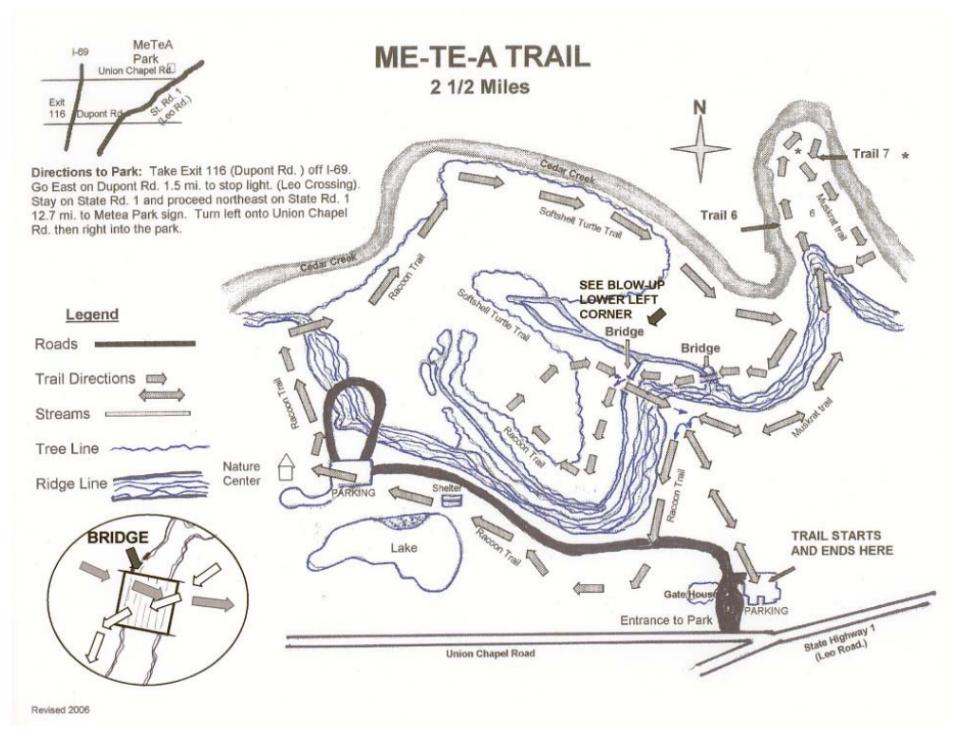
There are trail markers for some of the park's older wooded trails. Some of the park's newer wooded trails and the meadow/grassy trails aren't well marked at all. The park map at the main entrance, along with the map posted on the website are woefully outdated - they don't even show or mention any of the meadow trails. I searched the park website and couldn't find a map, but found an incomplete map after a google search and added it below (it was inside a boy scouts PDF and I can't figure out how to link it properly). I'll try to pick one up at the Nature Center the next time I run at Metea. All that said, there's no real danger of getting lost since the park isn't really that large.
Connections (0/3)
The park is entirely self contained and does not connect to any externa trails or sidewalks. I can see that the park now has a northern section that is only accessible from Hursh Road which has some trails of its own, but it is cut off from the original park area by Cedar Creek. I might update the review after I get a chance to run this northern section. If a bridge eventually connects the two areas of the park, it could be my go-to place for runs of 5-8 miles.
Safety (4/5)
Really nothing to worry about here. The park is staffed and well-maintained.
Family (4/5)
Jogging strollers and bikes aren't really an option here, but there is plenty for the kids to do here. Take turns running versus walking the trails with the kids or taking a dip in the swimming pond. There's a playground that looks safe, but has probably seen better days. There are some educational programs and maybe some day camps for kids in the summer. Cedarville Park has a fantastic playground and is just down the road if your family needs something more.
Extras (4/5)
In addition to the nature center, swimming pond, and educational programming, visitors are welcome to bring their dogs (if kept on a leash). So, Metea is a perfect place for you to have company on your run and also get some exercise for your dog.
There aren't any Strava segments (at least not until I make a few) for the park for me to highlight.
Metea County Park Run Review Score:
73% Great for a short and challenging run through wooded trails.