Pages

Showing posts with label Gravel. Show all posts

Friday, June 24, 2016

[Review] Metea County Park

Metea Park is located near Leo-Cedarville and is a surprisingly good option for a short and challenging  3-5 mile run.  The trails are wide, well-maintained, and offer a great break from running on the pavement.  The wooded sections give you some relief from the hot summer sun, and the mature environment basically made wind a non-factor.  You can bring your dog with you, and there's plenty for the family to do.  I couldn't recommend Metea for anything longer than 5-6 miles without getting repetitve, but I will definitely put Metea on my regular rotation of running spots for short recovery runs or for challenging tempo runs.

metea park marsh bridge

Cost (4/5)

$2 per vehicle for a visit.  Annual family passes are $30.  Can't get much cheaper than that.

Facilities (4/5)

There is a small parking lot near the entrance and a larger one near the Nature Center.  The nature center is open during normal business hours and has a restroom (and it has AC if you need to cool off in the summer).

Distance (5/10)

I used to run through Metea a lot in my High School days and was legitimately concerned that it would be difficult to finish a 3 mile run here, but I was surprised.  I covered most of the trails in the park and ran approximately 3.5 miles on this review, which was perfect for my scheduled short run.  I tend to hate running laps on a long run, but the scenery and terrain are nice enough that I could envision myself running 2-3 laps around the park without getting too bored.  I also wasn't very familiar with the trail system and may have missed some, as the park's website boasts 5 miles of trails. I might revisit this portion of the review after I run at Metea a few more times.

Surface (9/10)

The surface was fantastic and none of it was paved!  Most of the trails, except for a few stretches deeper in the woods, are more than wide enough for a solo run and would be good for a small group run as well.  The wooded parts are mostly dirt, with a few bridges and boardwalks peppered throughout.  Outside of the woods, the trail takes you through long grass meadows that are regularly mowed.  The park road running from the entrance back to the Nature Center is gravel, which provides a little extra (unpaved) running distance if you need it.

metea park meadowmetea park trail


Terrain (7/10)

For such a small area, you get a lot of variability in terrain.  I docked some points here because there are no extended climbs that will work for hill repeats, but the park is full of small rolling hills that can really add up to a challenging tempo run.  You're always going up or down and following the twists and turns of Cedar Creek - you won't get bored.

Scenery (4/5)

You get a lot here as well.  Wooded trails, views of Cedar Creek, swampy marshland, old oak trees, wild meadows, a small lake, and foot bridges.  I came upon a couple of wild turkeys, but they ducked into the woods before I could get my phone out for a photo.  I'm certain you'd see plenty of deer if you come here a lot (though I didn't this time).  If you need to take a break along the wooded trail, there are a few scenic turnoffs and overlooks with cool views of Cedar Creek.  I found this hiking video review on YouTube that shows off a little more of the park's natural beauty.

metea park cedar creek

metea park cedar creek

metea park nature center


Cover (4/5)

Aside from the open meadow area of the park, Metea has great cover from the wind and the sun.  The wooded trails felt nice and cool on a really hot day.

Traffic (10/10)

There are wide trails, no street traffic to deal with, and only a handful of other people were at the park when I ran through.

Markers (1/3)

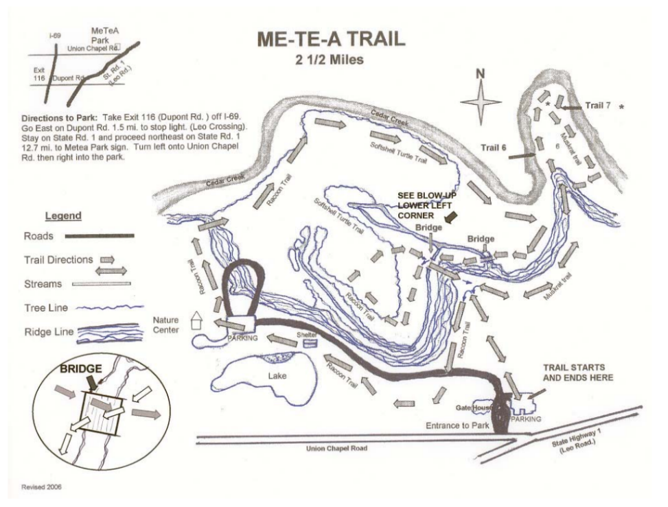
There are trail markers for some of the park's older wooded trails.  Some of the park's newer wooded trails and the meadow/grassy trails aren't well marked at all.  The park map at the main entrance, along with the map posted on the website are woefully outdated - they don't even show or mention any of the meadow trails.  I searched the park website and couldn't find a map, but found an incomplete map after a google search and added it below (it was inside a boy scouts PDF and I can't figure out how to link it properly).  I'll try to pick one up at the Nature Center the next time I run at Metea.  All that said, there's no real danger of getting lost since the park isn't really that large.

metea park map

metea park trail marker

metea park trail map

Connections (0/3)

The park is entirely self contained and does not connect to any externa trails or sidewalks.  I can see that the park now has a northern section that is only accessible from Hursh Road which has some trails of its own, but it is cut off from the original park area by Cedar Creek. I might update the review after I get a chance to run this northern section.  If a bridge eventually connects the two areas of the park, it could be my go-to place for runs of 5-8 miles.

Safety (4/5)

Really nothing to worry about here.  The park is staffed and well-maintained.

Family (4/5)

Jogging strollers and bikes aren't really an option here, but there is plenty for the kids to do here.  Take turns running versus walking the trails with the kids or taking a dip in the swimming pond.  There's a playground that looks safe, but has probably seen better days.  There are some educational programs and maybe some day camps for kids in the summer.  Cedarville Park has a fantastic playground and is just down the road if your family needs something more.

Extras (4/5)

In addition to the nature center, swimming pond, and educational programming, visitors are welcome to bring their dogs (if kept on a leash).  So, Metea is a perfect place for you to have company on your run and also get some exercise for your dog.

There aren't any Strava segments (at least not until I make a few) for the park for me to highlight.

Metea County Park Run Review Score:

73% Great for a short and challenging run through wooded trails. 

Tuesday, June 14, 2016

[Review] Devil's Hollow - Cedar Canyons Rd | Griffin Rd | Chapman Rd

This is one of my favorite places to run because of its challenging hills, long stretches of unpaved roads and trails, low street traffic, and its beautiful scenery. You can plan a great hilly workout or long run of almost any distance while soaking in some of Allen County's natural beauty in peace and quiet. [Note 6/14/2016: Pictures to come soon].


Great For:

Long Runs, Hill Runs, Hill Repeats

Not Great For:

Jogging strollers, tempo runs (I prefer a flat surface for those)

Cost (5/5)

Everything here is free. Parking at the ACRES Office (Dustin preserve) is closed after hours. There is a small parking turnoff a little bit West off of Chapman Road with access to the trails.

Distance (10/10)

Any. I have done runs of up to 15 miles in this area, but typically between 5-8 miles. You can stick to the roads, or cool off in the shade or take a bathroom break at the two Land Trust preserves accessible from Chapman/Schoaff Road.

Surface (7.5/10)

Gravel Road, Paved Road, Wooded Trails (optional). If you just stick to Griffin road, you can run almost entirely on gravel. The rest of the roads are paved, but the roadsides have small gravel sections that are wide enough to run on comfortably. The two wooded preserves have dirt trails, but if you don't like bugs you'll need to keep moving in the summer or wear some bug spray! This would get a higher score if more of the roads were full gravel instead of pushing you to the roadside to get away from the pavement.


Terrain (10/10)

This area offers everything you need for an interesting and challenging run. Flat stretches, winding wooded paths, steep hills, rolling hills, extended climbs, wooded trails, etc. You'll never get bored here and you can chart all kinds of different routes to keep it interesting.

Scenery (5/5)

This is one of the more beautiful and hilly areas I've seen in Allen County and it makes for a very peaceful and enjoyable run. You'll run down heavily wooded country roads that open into old farmlands and secluded properties.

Parking

I live nearby, so I don't have to worry about parking. However, there's parking at the Bicentennial Woods Preserve and the Dustin Preserve detailed at the end of this post. I have also seen cars parked off of Griffin Road, just north of Auburn Road.

Traffic (7.5/10)

I rarely see other runners, walkers, or bikers. Street traffic is extremely light (maybe 3-4 cars per run).

Cover (3.5/5)

If you run at the right time and along the right route, you can avoid the summer sun for most of your run. In the summer, I like to run early in the morning so that I can take advantage of the long shade cover from the roadside trees and bushes along most of the route. Cedar Canyons and the southern end of Griffin offer good shade cover, as well as most of Chapman/Schoaff Road between Bicentennial Woods and the Dustin Preserve. There are some stretches on Griffin road where the sun can't be avoided. Auburn Road, the eastern end of Chapman, and the northern end of Griffin are mostly farmland and don't have much shade and can get pretty windy. Obviously, the preserves offer a ton of great shade and wind cover.

Markers (0.5/3)

Obviously, road routes won't have any trail markers. The preserve trails aren't very well marked either, so your first couple of times running or hiking them might seem a little chaotic. However, the trails aren't that long or complex, so you shouldn't worry about getting lost.

Family (2.5/5)

This isn't the best area to run with your family or a jogging stroller, since it's mostly country roads. As I mention in other reviews, if there's a nearby attraction (playground or hiking trail) my wife and I sometimes bring our kids along and take turns running versus staying with the kids. Our kids love the Bicentennial Woods trail, which has an easy hike to a scenic bridge overlooking Cedar Creek. The creek is very shallow and the water runs slowly - so the kids can wear their water sandals and have fun throwing rocks and splashing!

Connections (1/3)

This route gets one point for connecting to the ACRES preserves. Other than that, there aren't any nearby trail systems right now and I'm not aware of any slated for future development.

Safety (3/5)

I usually run by myself and have never seen or experienced anything unsafe or threatening in this area. It is very low-traffic except for crossing over Coldwater Road or a small stretch on Auburn Road. I typically only have 3-4 cars pass by me on any given run. The trails can by very secluded, so use common sense if you feel uncomfortable going anywhere by yourself.

Extras and Intangibles (5/5)

If you can't already tell, I love the scenery and challenging, variable terrain of this area. You won't find a more interesting area to run in the immediate Fort Wayne area. If you know of one, please (PLEASE!) let me know in the comments. There are some fantastic hill segments to try out on Strava (described below) and the ACRES preserves are a real underutilized gem.

Devil's Hollow Run Review Score:

80% Really great area to run. Just needs more gravel roads and/or off-road trails.

Notable Segments

The Hill

This roughly half-mile stretch of gravel road on Griffin Rd. between Hollopeter and Chapman Rd is basically one big valley that offers one of the most challenging uphill stretches in the area. The hill is no joke - you'll climb about 60 feet and reach an incline of more than 15%. I found this segment on Strava and its name is fitting. This is a great place to do hill repeats and has very little car traffic.

Cedar Canyons Hill

This is really a beautiful and peaceful stretch of windy, wooded road. On early morning runs, I'll sometimes pass by a family of deer in the marshy woods on the north side of the road. The other side has some dramatic creek hillsides. The hilly part of this segment is also quite a challenge - you'll climb 50 feet and reach an incline of 10%. I wouldn't recommend this for hill repeats, as the hill has several twists and turns that make it difficult to see and hear car traffic. However, as part of a long, hilly run or workout I always hit this segment.


Griffin Road

This is my favorite place to do hill repeats. It has a long, challenging hill on gravel road with almost no car traffic. The main climb takes you up 55 feet and the incline is about 13% at its steepest point, and the entire segment gives you a climb of nearly 70 feet from its lowest point. It's another beautiful wooded stretch that opens up into some old farm properties. You can park at the end of Griffin Road, where it meets Auburn Road.


Other Highlights

ACRES Land Trust (Dustin Preserve) - Entrance is on Chapman Road between Coldwater and Griffin Rd. The preserve guide says 1.8 miles of wooded trails. The entry to the preserve itself is about 1/4 mile of nice gravel road with free parking. There's a visitor center, which I think has a bathroom.

Bicentennial Woods Nature Preserve - Entrance is on Shoaff Road just West of Coldwater Road and has a few free parking spots. The preserve guide says that this preserve offers 2.6 miles of hiking trails to run on.